


Thanks to Google Earth, we can find countless strange things on Earth that no one thought existed for a long time.
The strange images were discovered by Google Earth
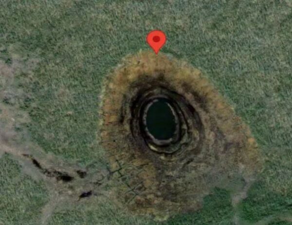
1. “Black hole” in the middle of the Pacific Ocean
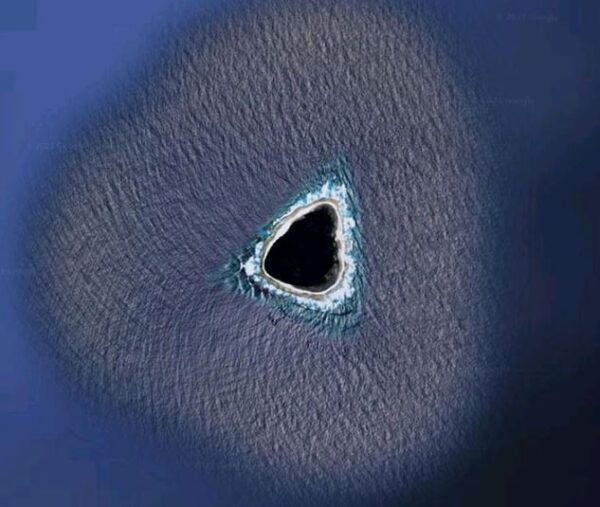
Image of “black hole” in the middle of the Pacific Ocean found using Google Earth. (Photo: Reddit).
In 2021, Kokoblocks – a user on the social network Reddit shared a photo found using Google Earth of a “black hole” appearing in the middle of the Pacific Ocean, causing heated debate. Some people commented that it was a black hole containing a secret passage to the center of the Earth. There are opinions that this may be a secret base that has been obscured.
Then the truth was revealed. The “black hole” in the photo of the Kokoblocks account is just an uninhabited coral island called Vostok in the Pacific Ocean. It is about 24 hectares in size, belongs to the sovereignty of the Republic of Kiribati and is located about 2,280 km east of Australia’s Sydney coast. The reason it looks like a “black hole” is because the dark green canopy of Pisonia trees – a genus of plants that thrive on Vostok Island – has created this misunderstanding.
2. Mysterious forest
Dr. Julian Bayliss used Google Earth to find a mysterious forest. (Photo: Google Earth).
In 2018, Dr. Julian Bayliss used Google Earth to explore the high-latitude tropical forests of Africa. Thanks to this app, he crossed to the north of Mozambique and used satellite images. Then he discovered a pristine tropical forest on top of Mount Lico.
His group climbed a 123m high mountain with a vertical granite face to observe this forest firsthand. They found a remarkable ecosystem with many species of butterflies, spiders and small mammals.
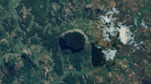
3. Hell hole in the forest
A mysterious deep hole was found in the forest in Abyysky district, in the Sakha Republic, Russia. (Google Earth).
A mysterious deep hole was found in the forest in Abyysky district, in the Sakha Republic, Russia. Around the hole, sand and soil automatically extruded and the dark rim inside the deep hole is a sign of previous intense scorching. According to scientists, this deep hole may be due to the Earth’s warming, causing gas to leak, leading to an explosion.
4. “The man” lies in the middle of the sea

Picture of “man” lying in the middle of the ocean in Australia. (Photo: Google Earth).
A group of people who specialize in using Google Earth cameras to search for strange things in Australia have actually found a mysterious image. This photo captures “a man” floating on the ocean surface in Southport, Queensland.
The truth was revealed later. Turns out, this is just a float for people going to Southport water park.
5. White horse
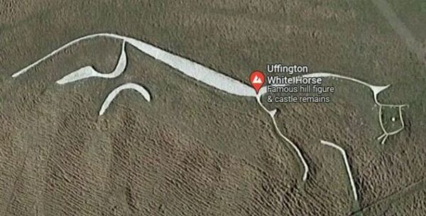
Image of a white horse painted with stone powder in England. (Photo: Google Earth).
After the photo recorded by Google Earth on the oldest hill in England was published, it surprised many people. A controversy has arisen over whether this drawing is a horse or a dragon.
The debate was so great that British historians had to get involved. According to their conclusion, this is the Uffington white horse with a length of 114m and a height of nearly 34m, painted with stone powder. This drawing is related to the legend of Saint George and Dragon Hill, a low hill located in the valley below White Horse Hill.
According to legend, this is where Saint George helped people exterminate a vicious dragon. Blood flowed out into the shape of a dragon, making grass unable to grow. The white horse was probably drawn 3,000 years ago, with the earliest document mentioning it being written in 1070.
6. “Whale” swimming in the pond
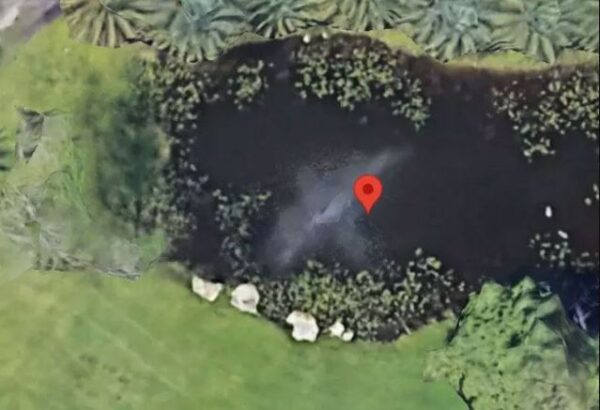
The photo captures a “whale” swimming in a pond on a farm in the US. (Photo: Google Earth).
Recently, a photo of a “whale” swimming in a pond was posted on social networks. It is known that this photo was taken on a farm in Southwest Florida, USA.
However, some Internet users have pointed out that this is just a fountain.
7. Mysterious “star”.
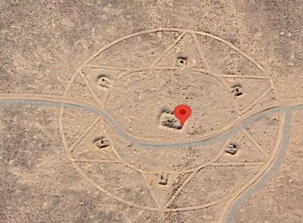
A 6-pointed “star” was found by Google Earth users in Pahrump, Nevada, USA. (Photo: Google Earth).
A 6-pointed “star” was found by Google Earth users in Pahrump, Nevada, USA. Most opinions believe that the place with this strange symbol is the US government’s anti-aircraft missile training site.
8. Comet over coral reef
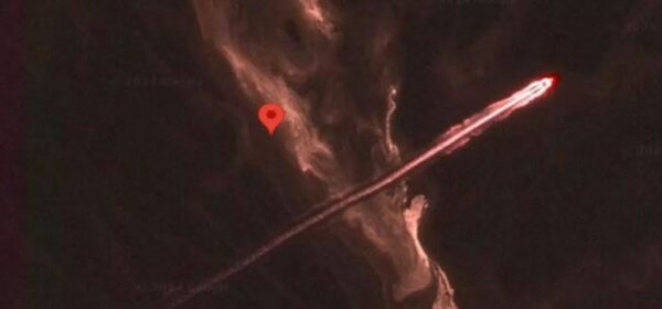
That is the image of a long red streak of light running along the coastal area of the Great Barrier Reef, Australia. (Photo: Google Earth).
In the coastal area of the Great Barrier Reef, Australia, some people used Google Earth and found a strange photo of this place. That is the image of a long red streak of light running across this area. To date, no one has determined whether this is a snapshot of the movement of a ship or the streak of light from a comet flying across this reef.
9. Triangular UFO
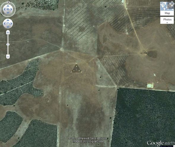
A photo taken by Google Earth, in Australia, is suspected to be an American UFO. (Photo: Google Earth).
In a photo taken by Google Earth, in Australia, at coordinates 30°30’38.44″S 115°22’56.03″E, a strange triangle with bright spots of light appears in the middle of the field. This area is located between Badgingarra National Park and Wongonderrah Nature Reserve.
Images of this UFO were first found in 2007. Some conspiracy theorists excitedly claimed that this was a TR-3B UFO. TR-3B UFO is an American aircraft codenamed ASTRA. The nuclear platform of the aircraft was built in the highest level of secrecy of the AURORA Program, funded with money from the “black budget” (at least 3 billion USD invested in this project).
“Aurora” is currently America’s most secret aerospace program, and the TR-3B is the most “exotic” vehicle created within the framework of the Aurora Program, funded and coordinated by the NSA (National Security Agency). National Security), National Recognition Organization (NRO) and CIA (Central Intelligence Agency).
However, many people believe that this is a fictional weapon that cannot exist in reality, and is all just an elaborate joke created on the internet by humorists.
10. Strange patterns in the desert
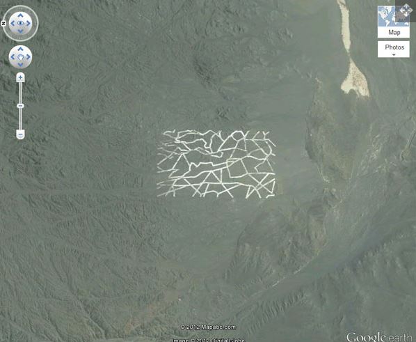
A strange pattern in the Gobi Desert in Mongolia was found by Google Earth. (Photo: Google Earth).
A strange pattern in the Gobi Desert in Mongolia was found by Google Earth. According to experts, this could be a military base with blocks used for many different functions such as weapons testing areas, radars or even testing areas for spy satellites.